martes, 22 de junio de 2010

Lago Atitlan and La Nariz

After having been holed up in Xela because of the inclement weather, I decided to spend some time exploring the surrounding area for the remainder of the week. So I caught the chicken bus to San Pedro del Lago. Catching chicken buses is somewhat akin to hitching a ride on a magic carpet. Your wish is their command...

I think the driver and "copiloto" have to provide a minimum revenue for the route they are plying and after this, they get to split the profits. It's hard to see they are rewarded in any other way as they are paid in cash and no tally is kept of the numbers on the buses and only very rarely is any form of ticket issued, although they must earn some kind of minimal salary too.. The copiloto must have a phenomenal memory for who has paid and who hasn't and where he has put their luggage on the roof. On the other hand there were so few foreigners travelling on these buses I guess it was easy to remember me.

So , one just had to utter one's destination in the market place before one was shepherded to a bus already pulling out. On asking if it was direct, the answer was always affirmative. In reality, they would do anything to get another punter on the bus. And so it was, that my direct bus took me first to km148, a well known interchange, from there I got a colectivo to Santa Clara and from there another chicken bus to San Pedro. Utterly miraculous in that it was seamless, the waits between buses minimal and the costs about the same and the timing only marginally longer.


View from the hotel balcony in San Pedro. A private room with private bathroom $6 per night! When I'd settled in, I started to practise the guitar, which introduced me to the Canadian couple next door, who invited me to go hiking with them very early the next morning. They were great company and very stimulating and bright. The downside is that the only Spanish I spoke was on their behalf or to translate for them. Tanya was very fit and went bounding on ahead. Jerome on the other hand was content to walk more slowly, which was a relief as I thought I would have had a coronary if we had continued at Tanya's pace. There were few other tourists on account of the recent storm, which made the place really enjoyable.

Jerome and Tanya... at the top of La Nariz
Looking out from the jetty at San Pedro
Looking across towards La Nariz from the balcony outside my room
Why this hill is called "El rostro Maya" or "La Nariz Indio".... Can you see the face in profile in this rotated photo. The hike took us to the tip of the nose.
The view from the top

Catching my breath
The so-called elephant's head in the background, with its trunk outstretched in the water

A svelte beatle on the way down...

lunes, 7 de junio de 2010

Volcan Santa Maria y Santiaguito

Having just lived through Tropical Storm Agatha, I was disappointed when another deluge struck and the streets of Xela (Quetzaltenango) were turned to raging rivers once more on the eve of our departure to Tajamulco volcano, the highest peak in Mesoamerica. I just acouldn't face the idea of camping in continuous rain and not seeing anything for the mist. This was a seasonal thundershower and not a weather system, so the next day was bright and clear; to say that I was gutted was an understatement as it was too late to make the journey. So I spent the time in Xela catching up with friends, practising the guitar, and having a massage. I decided not to waste the weather entirely and arranged to hike the next day up to the peak of Santa Maria, which towers 3772m above sea level, and also conveniently overlooks Santiaguito, the volcano it spawned in 1902 before becoming dormant. The hike itself was hard work above 3000m, the ascent was some 1300m or some 4000ft, about 1000ft more than Table Mountain.

At Llano de Piñar, the starting point a little mongrel bitch called Pinta, known to the guide joined us and frolicked all the way up with us, she knew that she was a soft touch for tourists and that we would be more than willing to share our breakfasts and water with her. Agatha had eroded the path into deep gulleys, and along with the fine pumice made the path difficult and slippery at times. It was somewhat depressing when a group of 3 local youths literally ran past us on the way to the top, they were well acclimatised to the altitude having lived here all their lives.

We were rewarded with awesome views of the surrounding cordillera as well as the Pacific coast far out to the South... The volcanoes of Antigua and Tajamulco and Tacana. A ringside view of the smouldering ashtray of Santiaguito, which belched steam every now and again. At 0930, almost as if you could set your watch by it, it erupted, with the sound of the roar of a jumbo jet engine. I was looking for a nearby airport until I realised what it was. It was wonderful to witness! By 10.00am the cloud cover had formed to the south and the view was all but obliterated.. What a worthwhile cause to get up at 0430 for! Absolutely stunning although I was utterly shattered after.
Pinta the Perra
The "Antigua" Volcanoes Acatenango and Fuego from the top of Santa Maria. Lake Atitlan is to the left of double peaked Acatenango, but not visible.
The start of the walk at 0510 on a beautiful Sunday morning with mists on the plain of Llano del Piñar and Xela
The smouldering "ashtray" of Santiaguito, taken from the peak of Santa Maria
At the summit of Santa Maria 3772m- On the horizon to my left are the volcanoes Tacaná (on the Mexican border) and Tajamulco which I walked up last Thursday and is the highest volcano in Mesoamerica.
Eruption! The sound of a jumbo jet engine on the takeoff roll (and I should know!)

sábado, 5 de junio de 2010

Antigua and Volcan Pacaya

Antigua is Guatemala's version of Hampstead. Although there is a plethora of language schools and is the favourite destination of students of Spanish, it seems that more English is spoken than anything else. It is a very charming town with myriad cafes and bars. The environs have much to offer, but with the rainy season starting , only wound up visiting Volcan Pacaya and Earth lodge. Earth lodge is a kind of resort with cabins set amongst the trees on the side of a hill, which made one feel as if one was actually living in the canopy. However, it was full of English speakers who though that speaking one or two words in Spanish and opening a text book now and then is a major achievement. There target market is probably Eco righteous north americans. As far as I'm concerned a grove of avocado trees , the excess produce of which is sold to a local market is hardly anything to write home about! I was also p'd off that they charged 25c for a glass of water with dinner. I suggested they get hold of a water filter. I was told that they had one, that before they built the lodge there was no water, no plumbing and that they needed the money. With the gushing publicity about the mountain water, it mostly struck me that as in Zim years ago, people with relatively small amounts of hard currency could open lodges, as the locals couldn't afford it themselves. The justifications though galled me, and although the food was good, I didn't feel like staying in a micro San Francisco in Guatemala....

The Plaza Mayor in Antigua
A close up of the bountiful woman in the centre of the square
The most charming thing for me about Antigua... ruins of cathedrals destroyed by previous earthquakes; the facades largely intact, but the rubble of the arches and the broken statues contained within
With the wind blowing towards me, the intense heat of the lava bed was too much to bear at Volcan Pacaya. The old guy behind me was chancing his luck as one could see red hot lava through the cracks in the bed. The month before a tourist died venturing to close to the crater and her guide died trying to save her. You never can know when " you're skating on thin ice". Pacaya erupted for the first time in something like 14 years a week ago last Thursday, killing 2 and shutting down the airport for a week.
The wind changed, so I was able to smile this time!
The sunset view of Volcanes Agua, Fuego and Acatenango on the way down from Pacaya

sábado, 22 de mayo de 2010

Semuc Champey

Semuc Champey is an utterly stunning spot, a set of pools at the bottom of a deep gorge, formed over eons as the river diverted itself underneath, eroding a tunnel underneath the pools through which the majority of the flow takes place. Below is the view from the Mirador. The hostel was at the entrance to the national park, although in a pretty spot and touted as an eco lodge, it was more a venue for prolonged piss ups in the evening. Sad because it would have been beautiful to experience the peace of night falling in the depths of the gorge. I would say that I'm now showing my age, but there were a number of young people who felt the same too. At least the 2nd night was better, and we were able to get some sleep, after the party animals had moved on... despite the best efforts of the staff to start another debauch.
It was a real adventure to dive off the waterfalls from pool to pool and swim in submerged caves under the overhangs of rock. There was a guide full of joie de vivre who led us on an exploration. Although I tagged myself to his group for free, I just had to tip him well after for a fun, exciting, but safe time. The limestone was treacherously slippery, probably as a result of some kind of algae growing on it.
Standing in the pools, little fish would come to nibble the dead skin off our feet. It was really idyllic. Americans pay fortunes for that kind of therapy.


The waterfalls where the flow from the pools spilled into the main body of the river underneath, at the end of the line.

Lanquin Caves

When I was at Tikal, I started chatting to a woman who gave me a recommendation to stay at "El Portal" when I went to Semuc Champey. The hostel was full on the day I arrived, so they put me in a sister hostel for the night and drove me out to Lanquin caves for free. The caves are deep and have electric lighting for something like the first 400m, just as well as I managed to leave my torch on my bed in a fit of absent mindedness. (Frightening to think what would happen without a torch in the event of a power failure; too easy to get lost in the labyrinth!) The stalactites and stalagmites are incredibly dramatic, and with the difficult light quite hard to photograph....
A stalagmite that appeared to me like a crouching jaguar on a pedestal.
Deep in the cave and dripping with sweat before making the return trip to the cave mouth. The rocks were incredibly slippery and hazardous, making progress slow. Another group came into the cave, the girls coped with the heat by removing their T shirts which of course enhanced the experience on the way out. Their guide had this talent for blowing down the handrails which were on the sides of some of the cat walks, making these moaning monster noises that echoed around the cavern and which were at first quite scary.

One of the highlights of the visit is to wait for it to get dark outside, and sit at the mouth of the cave. Some of the bats (and there are many, many) were already streaming out of the cave, but when the internal lights were switched off, it turned into a flood of bats moving so fast above our heads. All we had to do was to point our cameras in the dark towards the the cave roof to capture many of the bats. They are such fast and talented flyers, I loved the whooshing and high pitched squeaks as they swept by and how they were able to evade each other, us and rocky outcrops with rapid darting changes of direction. Didn't witness even one wipeout! A really lovely experience, although I couldn't help feeling a bit relieved to be outside again. The idea of being trapped and lost did not appeal, although the girls might have helped mitigate it.

Lacandon Forest Walk

The inspiration for this hike followed a visit to "Na Bolom" or the "House of the Jaguar", erstwhile home of Frans Blom Danish archeologist and explorer and Gertrude Duby, Swiss conservationist and photographer. It is now a museum and hotel dedicated to their life work of conserving th last rain forest in meso America and the way of life of the Lacandon "Indians" who were untouched by the conquistadores and had no contact with the outside until Frans Blom came across them on one of his trips. Many of the rooms in the place have exhibits of archeological finds from the Lacandon forest as well as examples of artifacts and clothes that the Indians were using in their daily lives, all made from the local plants. The best thing apart from the place itself which still had echoes of the very vibrant relationship that the couple had and their intellectual life, was the myriad photographs that Gertrude took of the Indians during their trips into the bush... So you see why I just had to go and see it for myself.

However, the reality was that I had a stinking cold in the stinking humid heat, but didn't want to miss the walk, which turned out to be a rather tame trek with other tourists to some unexcavated ruins in the forest, with a bit of a commentary on plants we saw along the way and then a dip in a brook on the way back. So the Indians remained undisturbed in their village which was apparently much deeper in the forest, in retrospect a fine thing.

The little accommodation area adjacent to the forest was owned/run by the local Indians, though their hospitality was legendary. Supper was a mingey 3 tiny quesadillas with spoonful of guacamole. We were offered a choice of a glass of water or some chamomile tea. I said I'd have the water and the tea after dinner. I was curtly told that I had had my one drink, and that was that... Really felt like Oliver Twist with a begging bowl. One cup of coffee for breakfast, no seconds....

The Huarombo[?] tree. The leaves are smoked to put you in touch with your ancestors. Smoke too much and you go loco for good...

Leaf of plant that handily grows close to the base. When dry this acts as good roll up paper for the Huarombo leaves...
Strangler fig [parasite] taken upwards through the inside, the host tree had long since died

An unexcavated temple on our walk, the pyramid underneath is buried by the forest


The swimming place. By sitting under the waterfall, you could have a refreshing shoulder massage, the water had such force and turbulence

lunes, 17 de mayo de 2010

Mayan Sites - Palenque, Tikal, Yaxchilan, Bonampak and Yaxha

Having read in a cursory fashion "In the Forest of Kings" which really inspired me and having been thoroughly fascinated by the ruins I'd visited so far, it was only natural that I'd make the pilgrimmage to the Mayan site of Palenque. I opted to take a tour which passed by the water falls of Agua Azul and Misol Ha, but given my penchant for pottering around, it would probably have been better to have given myself all day there.... The ruins are amazing structures in themselves,, made only with hardened wood and stone tools, yet the most poignant fact for me was that Palenque was the site where Linda Schele, one of the authors of "Forest of Kings" was fired up, when she saw the waterfalls there and the ruins. I made a pilgrimage to the little falls just because of that.


Agua Azul on the way to Palenque Don't be deceived by the apparent tranquility and solitude of the spot. It was over commercialised with stalls and food places squashed next to eachother and crammed full of Mexican families enjoying their Mayday puente.


Tlaloc mask at the base of Pyramid, Palenque. Tlaloc was the god of rain in Teothuacan, Xac in the Mayan lore.


Pakal's magnificent tomb, as seen from the Palace, Palenque here is a wonderful reconstruction along with the original artifacts at the Anthropology Museum in Mexico City


Stalgtite formed in over a 1000 years in the base of the T shaped window in the Palace at Palenque


Courtyard of the prisoners, in the Palace, Palenque. Where the hapless captives were displayed before meeting a grim fatem the record of their names together with the dates engraved on the monoliths

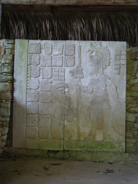
Engraving of a King in front of a captive pleading for clemency, with the glyphs that tell the story, Palenque

View from Temple of the Cross, Palenque, so called because of the beautiful fresco on the rear wall of the temple. The cross predates christianity in Mayan lore, relating to the creation myths where the gods fashioned humans out of maize. The cross arms had corn cob ends with human faces, the four cardinal points of the universe representing the north south east and west. East represented the birthplace of the sun...

The boat ride out to Yaxchilan on the Río Lacanjá

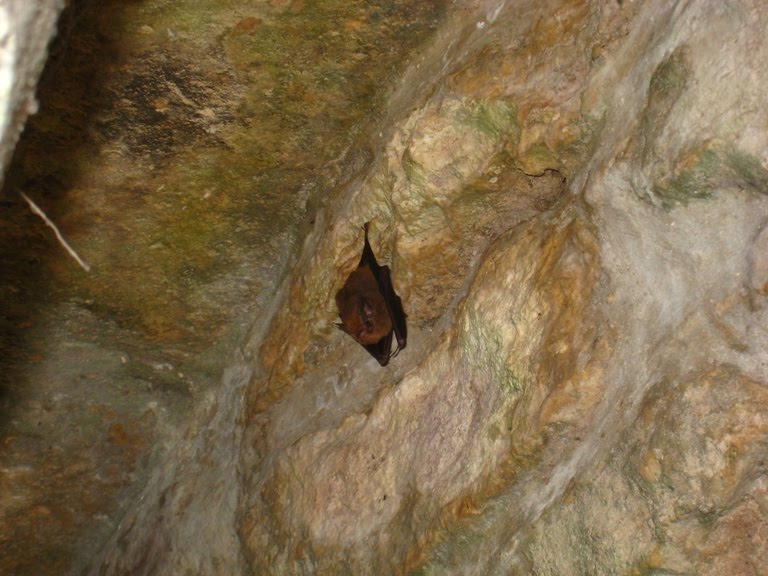
Bat in the "labyrinth" Yaxchilan

Beautiful engraved lintel in the doorway of a Temple Yaxchilan. Carved so that only the priest and the nobility allowed access to the temple at the top of the pyramid would see it.

Stela at the base of the Acropolis, Yaxchilan

Butterflies drinking on the river bank, just above the stones next to the water. Didn't know that they needed to drink...

Fresco with its colours after more than 1000 years of neglect, Bonampak. Although the pyramids appear white or grey, apparently they were once a very vivid red, with the sculptures and masks picked out on them in yellow and blue, black and white

Fresco showing captives begging for mercy having been tortured. The foreshortening in the painting is very sophisticated and would do Matisse or Picasso proud, Bonampak

Ornate lintel, Bonampak

The tall, restored Pyramid 5, Tikal

View from the top of Pyramid 5, you have to turn your head sideways to the right to see down the stairs, as I forgot to rotate the image (sorry!)

The view over the canopy from Pyramis 5, Tikal

Making friends with Inksy-Winksy. I have an aversion to creepy crawlies, but figured the best way to get over my fear of spiders was to hold a tarantula. I later went "fishing" for one, fortunately unsuccessfully! Tikal

Tlaloc mask, North Acropolis, Tikal

View from Temple of the Masks looking towards Temple of the Great Jaguar

Weaver birds' nests in the North Acropolis. These birds are much bigger and more colourful than their Zim counterparts, called "Oro pendula" here, because of the gold stripes down their bodies. They do this half somersault on the branch making a cry, quite spectacular, real show birds. Their nests are made of moss.

View through the canopy, Yaxha (Blue Water)

The top of the Pyramid from which we watched sunset, looking toward the Blue water lake, Yaxha